It has been over a year since I rolled into Portland with the dust of twelve states settling behind me. In that time I have remained faithful to using the bicycle as my transportation and have been far from stationary. My job currently has me commuting 41 miles each weekday, I've participated in a couple OR Randonneurs events and I've also taken several weekend joy rides with friends. Regardless, I haven't been very far from the city in all of that time. Until recently that is.
 |
| Cape Perpetua |
Dad and Denise came through Oregon on a road trip with their truck camper during the last week of August, so I gladly took a week off work and packed my new Velo Orange Polyvalent bike in their camper for a lift down to Crater Lake National Park by way of the Oregon Coast. We spent the first two nights camped near Nehalem and Florence respectively, and I took the opportunity to test out my new bivy sack under the stars during those mild nights.
 |
| Clockwise from top left: Devil's Churn, same, Sutton Beach, elk near Reedsport |
We saw many of the famous Oregon coastal sights including Fort Clatsop, Haystack Rock, Tillamook Cheese Factory, Devil's Churn, Oregon Dunes and some of the resident elk.
 |
| My dad, the intrepid photographer, at Devil's Churn |
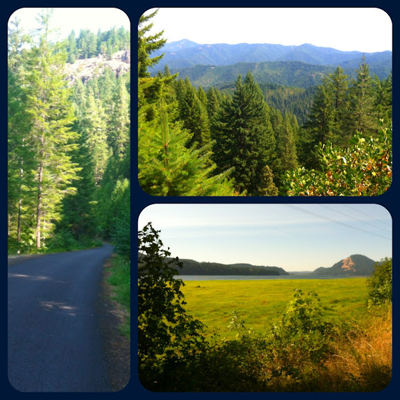
On the third day we turned inland, following the Umpqua River east toward the Cascade Mountain Range and into the Umpqua National Forest.
 |
| Clockwise from top left: me at Toketee Falls, 62-year-old redwood stave hydropower pipeline, Umpqua River |
We camped above 5000' elevation that night on the west shore of Diamond Lake under the gaze of Mt. Thielsen, watching the full moon rise over it's craggy peak. I set up my tent for added warmth as the temperature fell into the 30's that night.
 |
| Mt. Thielsen |
Diamond Lake has a nice 11-mile paved bike trail which circles the entire lake named after former congressman John Dellenback. I needed to get my legs moving, so I took the bike for a spin.
 |
| Clockwise from left: my Polyvalent at Silent Creek, trail marker, wolf lichen, Mt. Bailey |
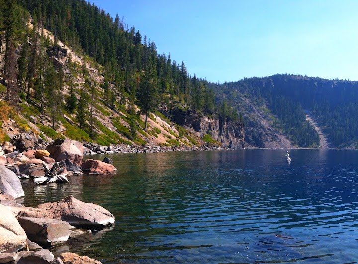
The following day was devoted to circling Crater Lake and stretching our legs on a few short hikes including a 700' descent down to Cleetwood Cove at the shore of the lake.
 |
| Crater Lake |
 |
| Crater Lake with Wizard Island at bottom |
 |
| Left: crater rim from Cleetwood Cove trail; Right: dead tree blocking sun |
 |
| Crater Lake's shore at Cleetwood Cove |
We spent the night in the Mazama Campground near the southern entrance to the park, arriving there shortly after visiting a collection of eroded fumaroles called the Pinnacles.
 |
| Pinnacles |
The next morning I parted ways with Dad and Denise on the north side of the park. They continued south, heading for the Redwoods in California, while I hopped in the saddle and began a fast descent down the Umpqua Scenic Byway toward Steamboat. In about two hours I had traveled the 45 miles dropping about 4000' in elevation, crossing through a nice stretch of fresh pavement and taking a short ride in a pilot truck through some active road construction.
At the Steamboat intersection I left the main road and began climbing into the forested hillsides along Steamboat, Canton, Martin and other small creeks. The Bureau of Land Management has a network of roads in this area which are mostly steep gravel paths going to former logging sites, but the single lane road which I navigated is one of the only paved ways through this stretch of land. The grade of the road seemed to increase with every mile as I wound my way back to 3800'. The feeling of isolation also increased as I traversed miles without seeing another person.
 |
| Canton Creek |
Eventually I crested a nameless ridge with a sweeping view of endless foothills and the road pitched down toward Sharps Creek where I began to see signs of human life in the form of gold panners. In the community of Culp Creek I hopped on the Row River Trail and rode it into Cottage Grove where I found a cheap motel for the night. The Labor Day weekend was in full effect and campground space was at a minimum.
 |
| Clockwise from left: Canton Creek Rd, Cascadian foothills, Dorena Lake |
Saturday dawned foggy and cool, but the sun cleared away both in a short time. I headed north into Eugene and passed through before the Oregon Ducks game brought out too many early tailgaters. On the north side of the city I began following the 132-mile Willamette Valley Scenic Bikeway which continues north via a network of flat back roads through farmlands and cities to the south side of Greater Portland. Just south of Brownsville I started to experience some rear tire trouble which plagued me the rest of the weekend, but I tried not to let it distract me from enjoying the beautiful fields of grains, vineyards, hop yards and orchards which lined my route.
 |
| Clockwise from top: Cottage Grove Moose Lodge, hop yard, Willamette Valley Scenic Bikeway sign |
I stayed in another motel in Albany on Satuday night making necessary repairs to my disintegrating tire. On Sunday I finished the final stretch of the Bikeway through Salem to Champoeg State Heritage Area and began navigating through Portland's neighboring cities. As chance would have it, my tire finally gave up the ghost as I reached the end of the Max train line in Clackamas. I boarded there and finished my three-day, 290-mile journey home by rail and foot.
 |
| Crater Lake National Park |